Chandra Scientific Industries -csidua
+91 9899955919 +91 9810094773 +91 8920878792
GST – 07AZVPD4989P1Z5
Nitin Dua
GST – 07AZVPD4989P1Z5

Chandra Scientific Industries
Call Now
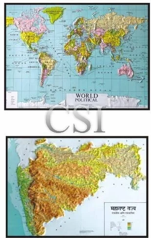
Maps 3D
Complete with hard backing, Aluminum frame frame with hanging hooks | |||
RR018 | Assam & Easter States Pol. cum Phy. | Size 75x100cms | English |
RR019 | Andhra Pradesh Pol. cum Phy. | Size 75x100cms | English |
RR020 | Bihar Pol. cum Phy. | Size 75x100cms | English |
RR021 | Gujarat Political | Size 75x100cms | English/Gujrati |
RR022 | Gujarat Physica | Size 75x100cms | English/Gujrati |
RR023 | Haryana Pol. cum Phy. | Size 75x100cms | English |
RR024 | Himachal Pradesh Pol. cum Phy. | Size 75x100cms | English/Hindi |
RR025 | Karnataka Pol. cum Phy. | Size 75x100cms | English |
RR026 | Maharashtra Pol. cum Phy. | Size 75x100cms | English/Marathi |
RR027 | Madhya Pradesh Pol. cum Phy. | Size 75x100cms | Hindi |
RR028 | Orissa Pol. cum Phy. | Size 75x100cms | English |
RR029 | Punjab Pol. cum Phy. | Size 75x100cms | English/Punjabi |
RR030 | Tami Nadu Pol. cum Phy. | Size 75x100cms | English |
RR031 | West Bengal Pol. cum Phy. | Size 75x100cms | English |
RR032 | Chattisgarh Pol. cum Phy. | Size 75x100cms | English |
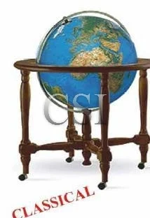
Globe Illuminated Classical
‘CLASSICAL’ Illuminated 2 in 1 Geographical globe mounted on a design detailsand a revolving solid brass meridian on 95cms height wheels allow easy movement |
Geographical blue colour GL017 Dia50cms height 95cms |
Antique Yellow Colour GL018 Dia 50cms height 95cms |
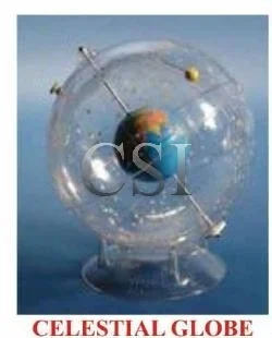
Celestial Globe(USA Make)
HUBBARD Transparent celestial Globe (U.S.A.MADE): This is large size globe of the celestial system showing the location of various atars and other celestial bodies. It clearly shows the milky wa and has a built in earth inside the globe which can be fully rotated by hand. |
HU001 Dia 30cms |
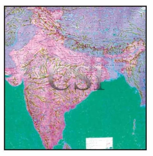
Maps 3D Nystrom
3D Raised Relief Plastic Model/Maps by Made in U.S.A. NYSTROM | |||
| With hard backing, Aluminum angle frame with hanging hooks | ||
RR014 | Asia 5 NR 3 | Size 122x110cms |
|
RR015 | United States 5 NR 1 | Size 165x120cms |
|
RR016 | North Africa 5 NR 5 | Size 105x140cms |
|
RR017 | Canada 5 NR 11 | Size 106x140cms |
|
RR018 | Africa 5 NR 03 | Size 122x110cms |
|
RR019 | Winsconsin 5 NR 21 | Size 110x92cms |
|
RR020 | Pennsylvania5NR22 | Size 100x150cms |
|
RR021 | World (Columbus Germany) | Size 140x92cms |
|
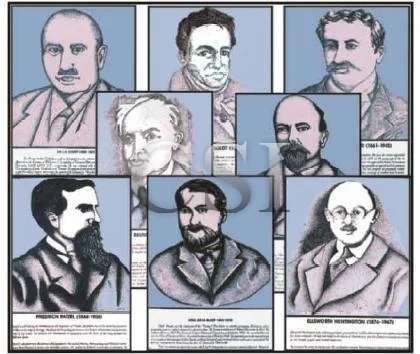
Geographers Life Sketches
Geographers photographs/life kketches With life history. Printed in color on thick rigid P.V.C. sheet, weather proof and washable plastic sheet with hard backing and an aluminum frame. Size 35x50cms ( Set of 8 ) |
GP001 Sir L.D. Stamp (1898–1967) GP002 Alexander V. Humboldt (1769-1869) GP003 W.M. Davis (1850-1934) GP004 Ellisworth Huntington (1876-1947) GP005 Jean Brunches (1868-1930) GP006 Halford J. Mackinder (1861-1945) GP007 Friendrich Ratgzel (1844-1904) GP008 Vidal De La Blach (1845-1918) |
Comparative Terrain Model
RR060 | Comparative Terrain Model: Set of 2 full colour landform models each includes an overlay representing ancient mountain Aorms that can be re moved and compared with the base model to show changes millions of year later. Cross section show basic mountain type, volcanic fault block, glaciated domes, and folded mountains includes lesson plan. Size 45x60cms |
|
|
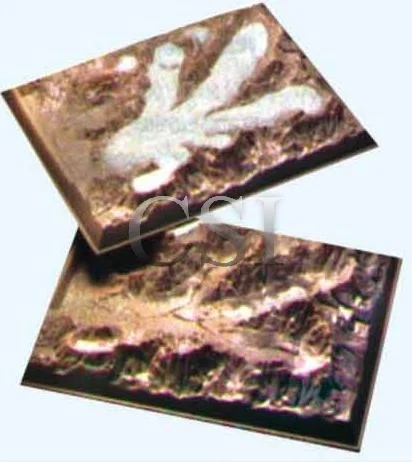
ALPINE Glacier Model
RR062 | ALPINE Glacier Model: Consists of two parts heavy plastic overlay of mountains terrain in rock colour wit snow and ice mass in white, second model of the same terrain shows post glacial conditions, Lower model may be filled with crushed ice and sand to observe glacial and sand deposition. Size 45x60cms |

Solar System Model
SOLAR SYSTEM AUTOMATIC REVOLVING WITH CD
GL020 | Cyber sky CD ROM Program is an exciting. Entertaining, and educational astronomy program that transforms your personal computer into your personal planetarium, Illuminated sun (9) planets including sun, mercury , Venus, mars Jupiter, Saturn, Uranus, Neptune and Pluto, automatic rotation, voice interactive |
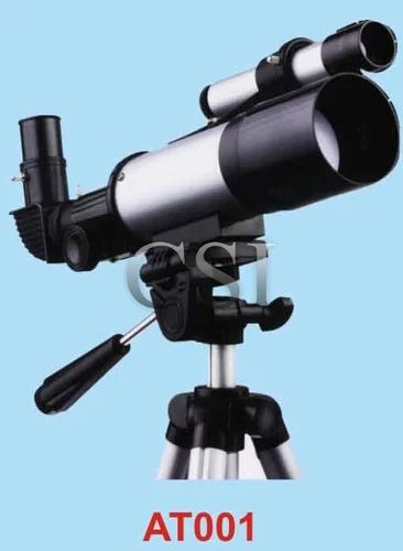
Terrestrial/ Astronomical telescope
AT001 | Terrestrial/ Astronomical telescope: Pan view sky series (t70060) right angled viewing for astronomical observation, 60mm objective, 2.5x,15x17x45x75x star finder scope, 225x50mm interchangeable eyepieces, terrestrial eyepiece for ground observation and robust full height retractable tripod. |
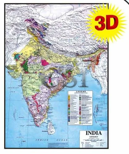
Maps By Geological Of India
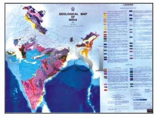
GG002 | Geological Map of India: Both side laminated with rollers. | Size 90 x 70cms 1:5 M Size 183 x 174cms 1:2 M |
GG003 | Mineral Map of India | Size 90 x 70cms 1:5 M |
GG004 | Metallogenic Map of India | Size 183 x 174cms 1:2 M |
GG005 | Tectonic Map of India | Size 183 x 174cms 1:2 M |
GG006 | Geotechnical Map of India | Size 183 x 174cms 1:2 M |
GG007 | Tectonic Map of India & Adjoining Countries | Size 90x70cm 1:7.5 M |
GG008 | India Rock & Mineral map | Size 54x88cm 1:6 M |
GG009 | India Rock type MAP | Size 54x88cm 1:6 M |
GG010 | India Ocean Geology MAP | Size 54x88cm 1:6 M |
GG011 | India Soil Texture MAP | Size 54x88cm 1:6 M |
GG012 | India Earthquake map | Size 54x88cm 1:6 M |
GG013 | India Soil cover map | Size 54x88cm 1:6 M |
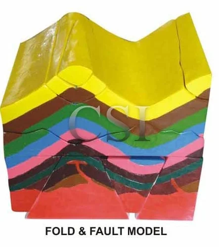
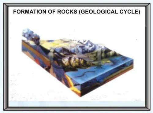
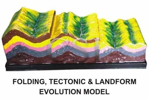
Fold & Fault Model
M3343 | Fold & Fault Model (Folding Tectonics and its Land form Evolution) : Model of Folding including two parts, or five pieces, demonstrating following contents: i) Original attitude of rock stratum-horizontal rock stratum and its age distribution-older from up to down. ii) The change of naked rock stratum after the action of external force; the longer the action, the older the rock. iii) The land form feature formed by folding tectonics and the change of land form. Size 45x20x14cm |
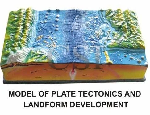
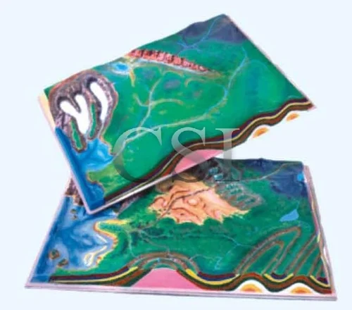
Plate Tectonics And Land Form Development
M3341 | Model Of Plate Tectonics And Land form Development : The five sides the model represents different contents and vividly illustrates the formation of the basic forms of the earth’s Surface- the deep-sea trench along the Western edge of Pacific, island arc chain, Himalayas, mid-oceanic ridge and submarine volcano; origin of folding and fracture-folded chains are formed by the plate collision. Size :- 60*31*15cm |
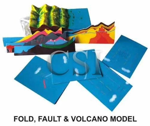
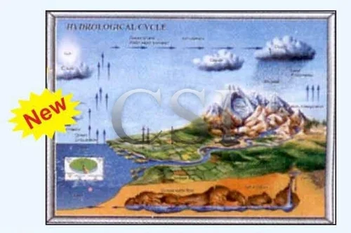
Fold Fault & Volcano Model
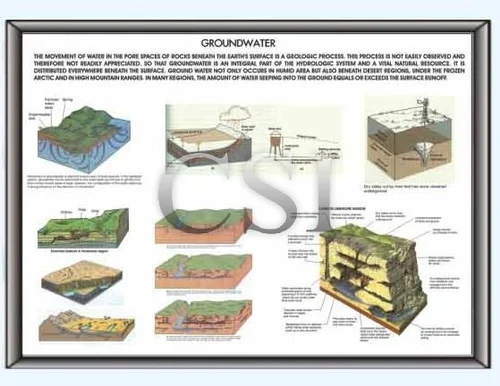
M3342 | Fold Fault & Volcano Model : It is three-dimensional model of natural relief of oceans and continents consisting of the seven sectional loose-leaf plates, namely, water circulation, water balance, the earth’s crust and its motion, crust structure, groundwater, diving of oceanic plates and underground heat. |
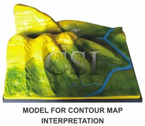
Contour Map Interpretation
M3409 | Model For Contour Map Interpretation: Various landforms are represented in layered three-dimension according to the contour map. The selected contents for this product include : crest, ridge, valley, saddle, precipice, stream, alluvial apron, flat slop and abrupt slope. Contour lines are depicted on the model surface, below which there are several dis mountable layers. Size 60x40cm |
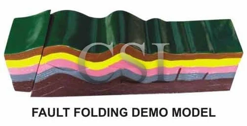
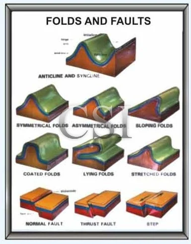
Fault Folding Demo Model
m3340 | Fault folding demo model: the model consists of three parts: the movable left part can be dismantled to demonstrate the fault, and the upper part can be taken off to display the distinct tectonic geomorphology of anticlinal valley and synclinal mountain formed by the erosion of external force. |
Maps By Survey Of India
S001 | India & Adjacent Countries: English scale 1 cms = 25 kms. |
|
|
S002 | Railway Maps of India : English or Hindi Size 104x81cms Scale 1:3, 500,000 |
|
|
S003 | Road Maps of India: 127x137cms (49’’x58’’) Scale 1:2, 500,000 (about 40 miles to n inch). All the roads with distances between important stations, places where Petri, board & lodging can be available. State Boundaries & Railway also shown. |
|
|
S004 | Political Maps of India: Size 82x92cm Scale 1:4,500,000 Multicolored showing important Routes, Railway & States and Districts Boundaries with their headquarters. Mounted on clothe rollers and varnished English or Hindi. |
|
|
S005 | Hill Ranges & Rivers : Scale 1:5 million |
|
|
S006 | Antarctica |
|
|
S007 | Map of the World Scale: 1:40,000,000 Size 100x70cms English only. |
Topographical Survey Sheets (Educational)
Size 56x90cms Laminated |
| ||
S011 | 45 D/7 : Banas Kantha, Sirohi Distt., Desert, River & Hill areas |
| |
S012 | 45 D/10 : Banas Kantha & Desert and Mountains |
| |
S013 | 45 F/3 : Jodhpur Distt.-Desert Dry area |
| |
S014 | 53 B/7 : Patiala-Plain surface, congested settlement |
| |
S015 | 56 D/11 : Gulbarga & Raichur Distt. – Plateau with river |
| |
S016 | 64 P/13 : Baudha Khondmals & River Ponds & Hill Ridges |
| |
S017 | 63 K/12 : Mirzapur & Ganga River plain |
| |
S018 | 63 G/15 : Allahabad & Plain area flow of Ganga & Yamuna |
| |
S019 | 53 J/3 : Dehradun (Uttrakhand) |

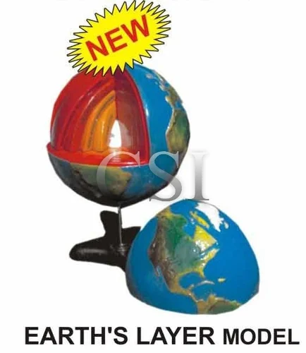
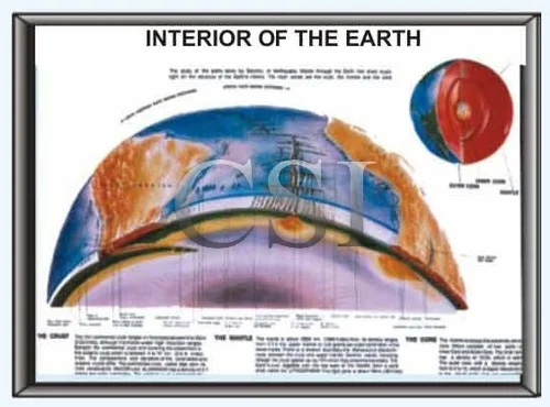
Earths Layer Model
EL001 | The model shows the layers in side the earth it is in seven detachable parts which indicate the indicate of the earth. The different colors are used to show the various layers. When we take off the upper part I.E. earth crust, we shall see inner core along with all layers in a single view, but we may detach all the layers one by one and find the periphery of each layer. On stand in C.B. Box |
Polyart Plastic Maps
| 1 | B.G. Polyart Plastic Maps of World, India & Continents: Untreatable weather proof and washable plastic surface fitted with plastic rollers. Size 75x100cms | ||
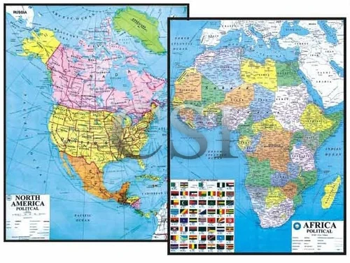
| PM001 World Political PM010 World Physical PM002 Asia Political PM011 Asia Physical PM003 Europe Political PM012 Europe Physical PM004 Africa Political PM013 Africa Physical PM005 North America Political PM014 North America Physical PM006 South America Political PM015 South America Physical PM007 Australia Political PM016 Australia Physical PM008 India Political PM017 India Physical PM009 Nepal Political PM018 Nepal Physical |
Extra Large Single Sheet Plastic Wall Maps
4 | Be Extra Large Single Sheet Plastic Wall Maps With Rollers |
|
|
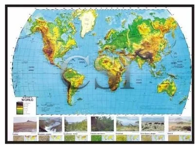
| World Environmental Map Size 150x100cms PM035 |
|
|
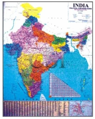
| India Political cum Road Guide Size 145x100cms PM036 |
|
|
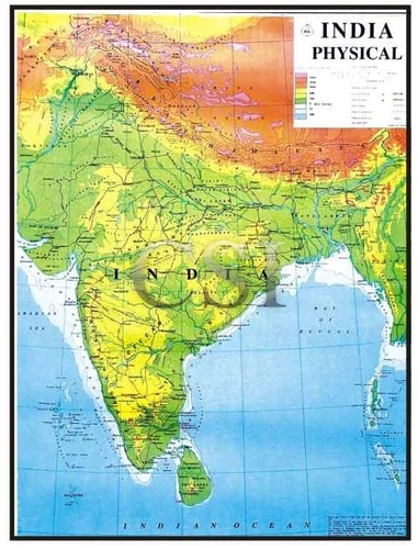
| India Physical: Showing in multicolor the physical details besides inset maps of India Physiographic, Geology, Soil and vegetation. A detailed map must for every school/Institution Size 145x100cms PM037 |
|
|
| Map of India Political cum Road Guide: Printed of polyart plastic nontearable, washable and markable sheet. Size 90x120cms PM038 |
|
|
| Map of World Political & Commercial: Printed on polyart plastic nontearable, washable & markable sheet showing the Air & Sea Routes Size 120x90cms PM039 |
|
|
| Time Map of World Political & Commercial (U.K. Print) : Single sheet map with laminated surface showing the air routes and sea routes, also showing the time zone size 101x151cms PM040 |
Weather Maps Of India
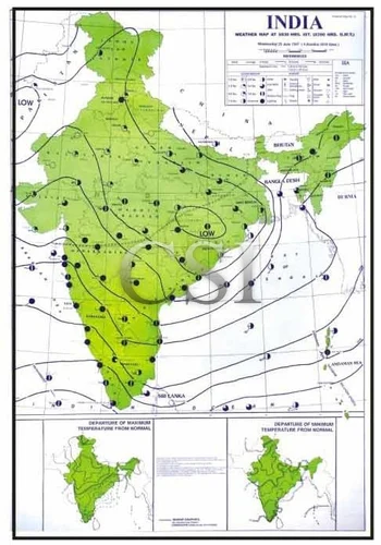
Printed in multicolors on white polyart sheet with superior quality plastic rollers showing weather conditions of the day and how to learn weather recording etc. Size 75x100cms Set of 12 |
|
| |
WM001 | 02 January (Winter) |
|
|
WM002 | 10 February (Winter) |
|
|
WM003 | !5 March (Autumn) |
|
|
WM004 | 13 April (Autumn) |
|
|
WM005 | 15 May (Summer) |
|
|
WM006 | 25 Jun (Summer) |
|
|
WM007 | !0 July ( Rainy) |
|
|
WM008 | 16 August (autumn) |
|
|
WM009 | 07 September (Autumn) |
|
|
WM010 | !9 October (Winter) |
|
|
WM011 | 12 November (Winter) |
|
|
WM012 | !0 December ( Winter) |